After much hard work, intense discussions, extensive public outreach, and a pandemic, we’re finally ready for public comment on the draft MARTA “NextGen” bus network redesign, whjch covers Atlanta and the neighboring cities in Fulton and DeKalb Counties. (Clayton County is also part of MARTA but being addressed by a different process.)
The project website has all kinds of maps and useful information. But if you’re curious, I hope you will delve into our readable full report (download high resolution pdf, or view low resolution pdf). There you’ll find a complete explanation of the thinking that led to the proposal as it stands.
This is the first complete rethinking of the bus network since the MARTA rail system opened 45 years ago. Back then, the core idea of the network was that the purposes of buses was to feed the rail system, producing a network overwhelmingly suited to bringing people into downtown Atlanta. But since then, much has changed about the region and it transit demand:
- Many suburban employment and activity centers have developed, some of which are well suited to transit service.
- The rise of working from home after Covid-19 has reduced the downtown rush hour commute market.
- The need is greater than ever for all-day, all-week, all-direction trips that matter to lower income people. Many of these trips are not going downtown, but to activity and job destinations all over the region.
We have done our best to redesign the network reflecting these changes. Big ideas include:
- More lines that run frequently (every 15 minutes or better) all day and on weekends. These are in red on our maps below.
- More lines that continue past rail stations instead of ending at them, to connect more destinations with fewer transfers.
Is this all of the service that the service area needs? No, it is what MARTA can afford, given its other commitments and the decisions that have been made about priorities. MARTA directed us to plan for a total service budget that is slightly lower than 2019 though higher than 2023. I wish we could have proposed far more service than this.
Still, within these constraints, the plan achieves some dramatic improvements. Here is the Fall 2023 network on the left, which we used as a baseline, and the proposed “NextGen” network on the right. (These are just diagrams. Much more detailed maps are on the project website and in our report.)
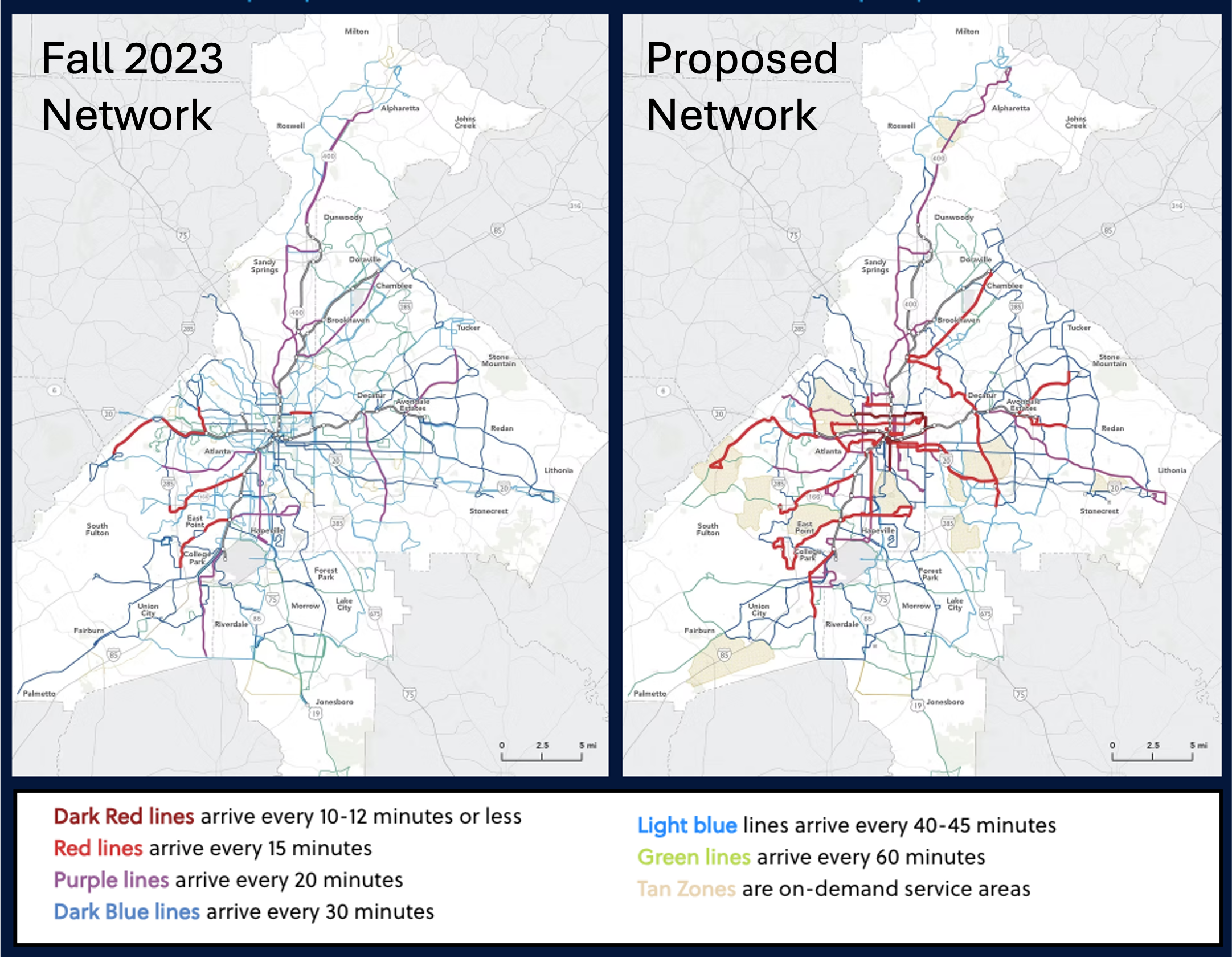
Some key facts:
- The average number of jobs reachable in an hour goes up by 21% for all residents, 23% for racial minority residents, and 23% for low income residents. (Why does this matter?)
- The number of residents within 1/4 mile of service goes up by 2%.
- The number of residents within 1/4 mile of frequent service (every 15 minutes or better all day, shown in red above) goes up by 245%.
I hope you’ll take the time to peruse our friendly report, which talks through the whole thought process and explains how we got to this recommendation. Then, if you live or travel in the MARTA service area, please comment! MARTA is taking comments through February.
I appreciate the work that has gone into this, but what makes me nervous is that the high reliance on connections doesn’t seem to take into account the reliability of the network.
MARTA bus service is extremely unreliable. Personally, since August 1, I have had a bus cancelled on me on 24% of the days I have used it. In a low reliability system, reducing the # of routes like this just lowers the bar. I look at this map and, frankly, looking at the route I use most frequently, feel hopeless. I wish the MARTA Board rode MARTA buses and could understand how tone-deaf this kind of proposal is.
Nice plan.
But I did not realize how pathetic MARTA’s service coverage is until I saw the stats in the plan. Only 30% of the service area population is within walking distance of transit. That highlights why transit in American continues to fail. Most people cannot even use it if they wanted to.
American transit systems need coverage standards like almost every other county has, that calls for 95% of the population to be within a certain walk distance of transit service.
95% coverage sounds great in theory but it would be incredibly expensive given how sprawling American cities are, the ridership/coverage trade off is extremely strong because of this here. You could theoretically achieve 95% coverage but many of those routes would be extremely low ridership.
This looks worse in Atlanta than in most US cities because MARTA uses a walking distance standard of 1/4 mile along the street network, which is really short. The Atlanta area has many people living in places where it would be physically impossible for transit to run that close to them, even if it were efficient to do so.
I appreciate the increased frequency. 10 minute frequencies almost eliminate the need to plan.
“That highlights why transit in American continues to fail. Most people cannot even use it if they wanted to.”
Depends on your definition of “fail”. MARTA could easily make their service *available* to more people by making the service less useful to anyone who does ride it; see https://humantransit.org/2018/02/basics-the-ridership-coverage-tradeoff.html.
It’s a shame this lowers job reach by 7%. How is that an improvement? You’ve got a bunch of streets, Clairmont or North Decatur for instance, that have been cut up into dis-connected pieces. This doesn’t seem to follow good transit planning. The job and event access shows bright red holes in North DeKalb and around Fernbank. Also, why is there a super frequent bus seemly to the middle of nowhere from Avondale?
As Jarrett notes, this 7% reduction is coupled with an increase in service frequency in the remaining areas. And I should imagine that the more service there is, the more the remaining jobs are actually served well, thus creating an increase in opportunity nevertheless. Just my guess.
I’m not trying to be glib, but as someone whose family will be massively impacted by this, I keep circling back and I genuinely am curious-
How many rides on Atlanta’s bus system did you take while designing this, and which routes? Were they time-sensitive trips?
I already know MARTA’s Board doesn’t use the buses, but I want to know whether the folks working on this network have.
This network is a collaboration among many professionals, at MARTA, the cities, and the consulting firms. My own role is not to bring the local knowledge; that’s why we worked with local partners. I do ride buses in most cities where I work, but this was difficult in Atlanta because so much of the planning happened during the pandemic, when we were doing everything over Zoom.
In any case, this current phase is everyone’s opportunity to share their perspectives, so I hope you will do so through the MARTA site that I linked to.
I have shared my feedback. As someone who cares deeply about transit, I respect the work and experience you bring to the table. But when I say that the bus has been cancelled on me over 25% of days we have taken it since Aug 1, does that match information your “local” contacts have brought you? Don’t be credulous.
Its not like the network proposed by the team is the ideal one
” Is this all of the service that the service area needs? No, it is what MARTA can afford, given its other commitments and the decisions that have been made about priorities. MARTA directed us to plan for a total service budget that is slightly lower than 2019 though higher than 2023. I wish we could have proposed far more service than this.”
If you want better service, tell your city, county and state reps you want more funding. Or vote for those that do in the next election. Or face the alternative where Louisville had to cut 50% of its transit budget because no politician in Louisville is willing to give more funding.
Fantastic improvements. What’s not to like? Thank you
SMARTER
Redesigned bus network that is easier to navigate
Simplified routes that reduce the need for transfers
FASTER
Reach more places in less time
More frequent service with buses arriving every 15 minutes or less
BETTER
A more flexible, accessible, and faster bus system
Greater accessibility with new on-demand service launching in key zones
Thank you, Jarrett. I worked with you at NN in Portland briefly in the 1990s. I’m happy so see you working in ATL. I have been a planning consultant in Atlanta for the last 20 years, working on many MARTA studies, CTPS and transit plans. The MARTA network is a tough nut to crack and I’m looking forward to delving into the Draft Network Plan. My two cents: Reduce density of bus stops. Many local routes have stops every block (200-300) ft.