Whenever I talk about the value of grid networks, as I did here, someone always says: But my city isn’t a grid. For example, Sydney, where I live now, is about as ungridlike a city as you’ll encounter. In fact, there’s no large system of order in Sydney’s road network at all. Some roads follow what were once Aboriginal tracks, but mostly it just grew, one bit at a time, an accretion of millions of short-term decisions.
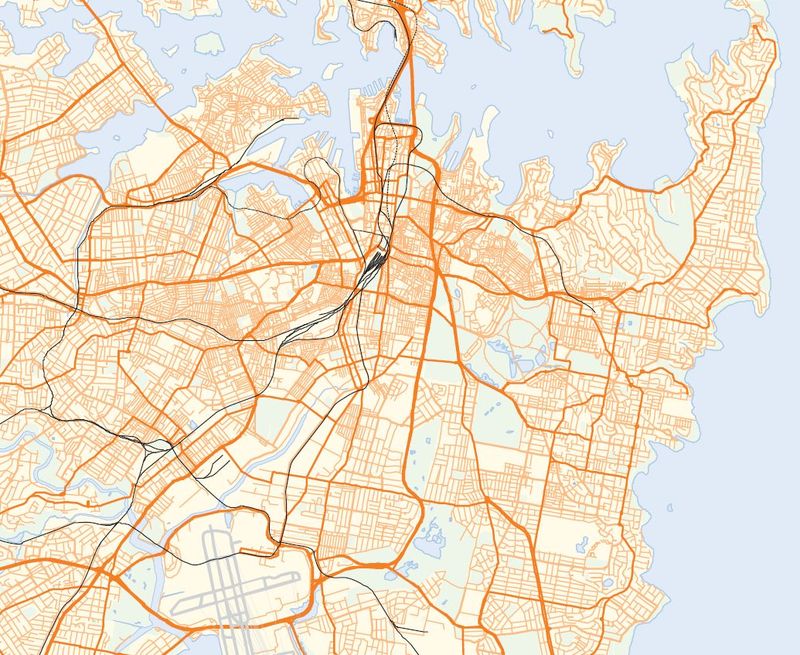
One of Sydney’s biggest problems is that the road network is so focused on the CBD (the Central Business District located top-centre in this image) that traffic is forced into the CBD that doesn’t want to be there. But the problem is much, much worse if you’re a transit passenger. As part of the Sydney Morning Herald‘s Independent Public Inquiry, discussed here, I did a quick review of the inner-city bus network looking for the pattern of frequent service — service that runs every 15 minutes or better all day. The frequent network is the portion of the network where you don’t have to worry about a timetable, and where transit can therefore be used with some sense of spontaneity and freedom. To my knowledge, nobody had drawn a map of inner Sydney’s frequent network before. It turned out to look like this:
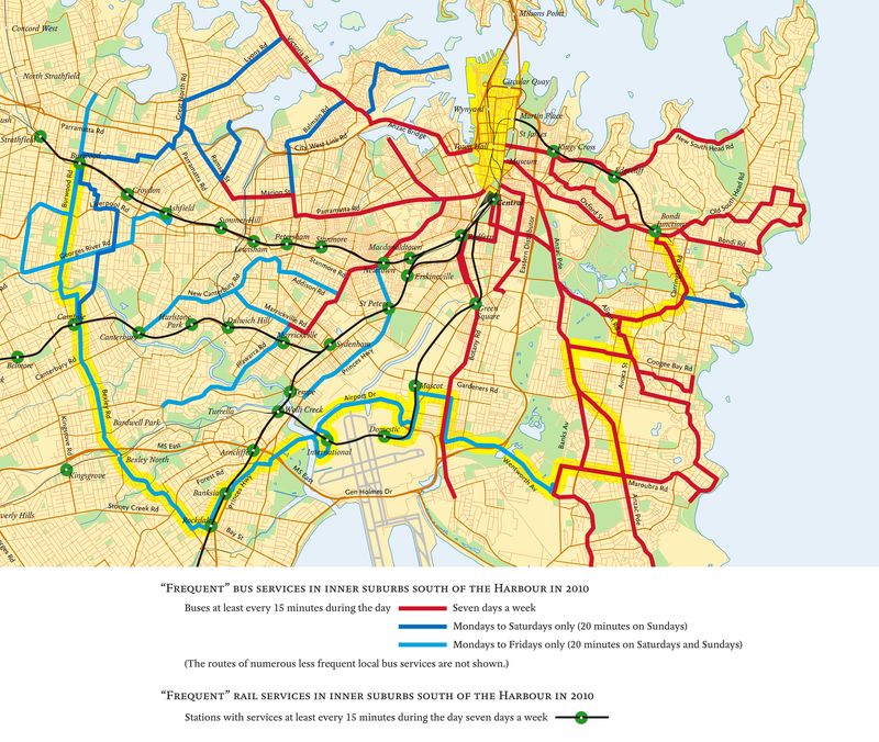
If you want to get around with any spontaneity in the inner part of Sydney — where densities are highest, obstacles to driving are greatest, and car-free lifestyles should be most attractive — the network forces you to go through the CBD (the yellow wedge on the north edge of the drawing). In the whole inner city of Sydney there is only one frequent crosstown or orbital service — one that runs perpendicular to the radial lines, like the circular element of a spider web. It’s highlighted in yellow. By contrast, most major North American and European cities have a whole grid of these orbital services; they are often the most productive routes in the network, in terms of ridership per unit of operating cost.
As part of the inquiry, I sketched a map to give just a taste of what an inner city frequent grid network might look like for Sydney. It’s not a proposal, just a possible starting point for thinking about one. But if you can’t imagine doing a grid network in a gridless city, you might find it interesting to stare at for a bit. (All this is in the Preliminary Report of the Inquiry, in Section 4.2, and readers interested in the local detail are encouraged to dig there.)
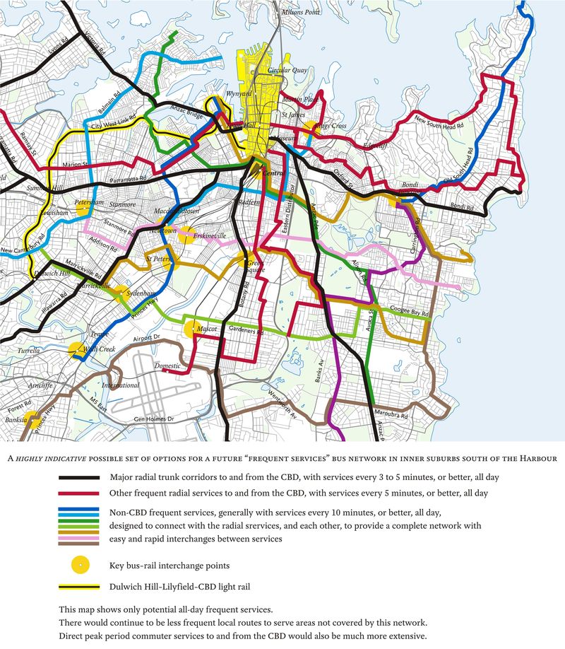
Sydney’s road network is so radial, and the CBD is such a large destination, that the grid takes more of a spider-web form (as defined here). I highlighted this in the diagram by using black and red for radial lines and all the other colours for orbitals, so that people could see how orbital services might work and how they could all fit together, with each other and with commuter rail and light rail, to form a complete inner city network.
But in the middle part of the map you’ll notice some lines that do try to run straight east-west, even though the lacerated street network requires you to make many turns to keep going the same direction. As I explored in more detail here, most grid networks involve a fusion of standard rectangular grid lines and spider-web (or polar grid) lines. The rectangular lines express a “serve everywhere” impulse, while the spider-web lines express a “focus on the centre” impulse. Network design is a process of finding the balance and making them work together.
There are many ways to design such a pattern for Sydney. A detailed planning effort would feature months of work exploring various options, but what I sketched here, based on three years’ observation of the inner city and about three hours of focused thought, is at least a step toward visualizing the future.
So yes, your city may not be a grid. But still, if you want a transit network that’s useful for going at high frequencies from anywhere to anywhere, the answer will be some kind of grid, built on connections, with some mix of rectangular and spider-web elements, all fitted with more or less struggle to the unique shape of your city.
Your current situation map shows two very painful sectors:
1) no bus services crossing the rail network between Newtown and Burwood. Generally to travel across this axis without travelling as far as Broadway requires walking for 10-20 minutes in order to connect bus services. I was forced to test this one day, when I found it was faster to walk 6.5km from Marrickville to Balmain than take public transport (on a weekday morning).
2) the area between CBD and airport bisected by South Dowling Street/Southern Cross Drive. The absence of cross-city lines here means that all transit traffic bound for UNSW or the beachside suburbs is funnelled through the CBD.
And of course the whole mess is exacerbated by the requirement for paying a new fare with every connection. So any potential cross-town fare is forced into 2 x radial fares.
I was hoping the new MyZone tickets http://www.myzone.nsw.gov.au/ would address that but AFAICT there is absolutely no fare or ease-of-use improvement for bus riders other than those who ride private buses.
I assume the frequent service network wouldn’t run 24 hours a day. What do you consider appropriate hours for a frequent service network in general, something like 6 AM – 8 PM.
Jarrett,
Existing bus services on major radial corridors, continually struggle to meet demand to and from the CBD during peaks. It would be hard to divert resources to frequent cross-suburban lines if the patronage didn’t justify it. I understand your grid proposal is for illustrative purposes only, but the same anchoring principles you mentioned earlier would need to apply to both the radial and cross-suburban lines – and the grid would need modifications to ensure lines didn’t come into proximity to but bypass major destinations like Sydney Uni/Broadway Shopping Centre. Although I understand the function of the frequent network in facilitating multidestinational travel, and that there is network redundancy in this type of system, but do you think that generally, each route should also be able to perform in its own right? I’m not sure about the provision of full time high frequency services along routes that offer little patronage potential in off-peak times and on weekends – there are perhaps some on your map and Pyrmont is definitely overserviced!
I have the same question as John. What times are the cutoffs for frequent service?
@ Ed O,
I’m not sure it’s always a case of diverting resources from peak hour radial services. A lot of the benefits of cross-town routes can be seen during off-peak periods throughout the day, at night and on the weekends when people want to get to shops, cinemas, parks, restaurants etc. Even during peak periods they can reduce the radial demand by avoiding the need to interchange in the city.
As Jarrett notes, cross-town services can also be very productive in terms of trips per km, as they tend to see lots of turnover of passengers along the route, serve a useful purpose in both directions, and can show more evenly distributed demand along the route. In contrast, many city-bound services get one passenger per seat per run, and the demand profile steadily increases towards the city with a lightly loaded back-haul run.
@Ed O. Yes, Matt hit the key points in response to your comment. In addition, I’d emphasise that I’m not sure anyone knows how many of the people who ride buses into the greater CBD (including Central Stn) really want to go there, and how many are forced to go there because the existing frequent network is so radial.
For example, a friend of mine commutes from Randwick to a job near Hurstville rail station, and he finds the only way to make the trip reliably is to go via Central, way out of direction. He’s being counted as part of the radial demand when in fact he wants to be an orbital passenger.
Cities that do good grid systems still have plenty of peak service into the CBD, but that service is sized to the volume of people really going to the CBD, or making a connection for which the CBD is on the way.
@Alon and John. How late Frequent Service runs into the evening is a local decision. The principle is that you want Frequent Service to be a reliable brand, so you want a consistent definition, and that tends to lead to one that ends fairly early, even though your strong nightlife lines will run much later.
Short answer: It varies, but that detail isn’t a reason to give up on the concept of frequent service branding, at least for daytime service.
Jarrett: okay… which times have been used in the past in cities you’re familiar with?
I'd say the minimum Frequent Service definition covers something like 7:00 AM – 7:00 PM weekdays, typical of small metro areas, say under 500,000. Bigger cities can usually support a seven-day definition that goes later into the evening. Most articulate an ideal of a network that runs at least 18 hours a day, say 6:00 to midnight, and usually 7 days a week.
Matt and Jarrett, you perhaps miss the point of my comments. There are numerous existing cross-suburban bus routes in inner-Sydney, and I’m not questioning the desirability of a frequent grid, or the desirability of avoiding the CBD if you don’t need to be there. What is of concern is the type of intense and very expensive 18/7 frequent network envisaged by Jarrett, which may not necessarily align with landuse or activity patterns, or the way large numbers of people want to travel in this inner area.
In addition to Sydney’s CBD being such a strong destination, other major destinations in the inner-city, (universities, shopping centres, cinemas, restaurants etc) are located on the major corridors into the City (eg Broadway, Oxford Street), meaning that by day and night, radials carry more than just CBD workers. Activity patterns, density and transit demand in inner-Sydney are highly aligned to the radials and this is where the landuse-transport synergies are, and where the high-frequency public transport services need to be. Inner-Sydney is not a level playing field of uniform density and dispersed landuses over which you can just throw a regular, albeit modified, grid. An alternative option may be to provide far fewer, but more significant frequent cross-suburban routes that not only link the radials, but hit the more important rail stations (rather than local stations) and have strong anchors (rather than ending at low-density residential non-destinations) that give the routes a fighting chance of success, instead of adhering to an idealised network layout of regularly spaced lines, irrespective of the urban geography.
Jarrett, your friend in Randwick has the choice of riding the famous frequent limited stops 400/410 service to Rockdale, where he can change for a train to Hurstville. This frequent bus service would take him pretty much in the direction he wants to travel – and yet he still chooses to travel via Central, probably because it’s the quickest way of accessing the much faster CityRail system. This tests the frequent grid concept in terms of travel times achievable under Sydney traffic conditions and interactions with the much faster CityRail network. Could the frequent bus network you envisage allow your friend to access an alternative Illawarra Line station (Sydenham or Rockdale) more quickly than Central Station? Probably not.
Finally, I’d say that many people in inner-Sydney actually benefit and want to travel via Central Station, and there probably wouldn’t be a better hub to be forced to travel through. This is a hub and spoke network thing. Central provides a whole galaxy of destinations and travel options by transit across the whole metropolitan area, whereas if you caught a frequent cross-suburban bus to Erskineville or St Peters Stations (second and third stops from Central on the local Bankstown Line) you wouldn’t be heading anywhere very fast.
Ed O.
Yes, there’s lots of room for disagreement about the exact extent and density of the grid that inner Sydney needs. My sketch may have too many orbitals; in a budget-constrained detailed planning process, I’d probably argue for fewer, stronger ones, but I do want dense places (residential or commercial) to be within walking distance of both a radial and an orbital, so that people have a direct path to anywhere they might want to go, not just in the radial direction and not just via Central or the CBD.
Many of the most important orbital routes already exist in some form but lack the frequency and duration to make connections easy and reliable, and therefore don’t show up on our frequent network map. This is crucial because successful orbital services depend heavily on connections.
I agree that density in the inner city is still uneven, but many dense areas have poor service because they don’t fall on strong radials. Mitchell Road Alexandria comes to mind. That’s an area where the radial system doesn’t work — the area can’t support and doesn’t need a route all the way to Circular Quay but it could support a strong orbital route with strong connections. Instead it has two infrequent orbitals (355, 370) and an absurdly infrequent radial (308, every two hours much of the time).
In fact I think the 308 should be a tourist attraction, as it may well be the most infrequent inner-city bus route in the developed world. I can’t think of anything like it in any North American or European city I’ve studied. It’s infrequent because most of its time is spent duplicating other routes into the city instead of providing the unique link across Alexandria where it’s needed. The geography suggests this would logically be in the form of a frequent orbital, and thus integrated with other orbital markets to form an east-west link all the way across the grid.
No question that at CityRail’s current levels of service, the concentration of service at Central is useful and sometimes worth going out of the way for. However, in the Inquiry I was thinking in conjunction with two other crucial Inquiry recommendations — eliminating the transfer penalty and dramatically increasing all-day CityRail service on the inner parts of the network, which would raise the demand and viability for connecting bus service to dense inner city stations like St. Peters and Newtown. I was also thinking in terms of City of Sydney goals to reduce the need to own cars. Voluntary transit dependence requires a network that’s simple, connective, and takes you anywhere in the inner city, not just the CBD.
Thanks for the thoughtful comments on this!
…and the radials still force bus travellers to pay 2x fares into CBD and out because of the way Sydney’s ticketing works.
As a footnote, I’ve read a lot of comments on Bang the Table community sites in Sydney and noted that since so many of Sydney’s rail stations are inaccessible to anyone with personal mobility issues, that buses are the only feasible public transport option.
Your mention of the 308 bus-route reminds me of the horror-story that the 389 used to be. It shares start and end points with the 380, and one bus might flip between 380/389 through the day. It seemed that the 389 was the loser in this respect as drivers would forget to switch to this route, thereby making it even less frequent. Having lived on this route 4 times in my life, the unreliability was an ongoing irritation until I gave up and got a car…
I wonder if the 308 falls prey to the same switchover syndrome.
Just this last month, with a lot of return trips to shows at the Opera House, I noted a similar problem with the 422/423/426/428. A bus starts at Circular Quay Stand A, but the front of the bus says X, the side of the bus says Y, but Z is time-tabled. Sometimes the passengers clue the driver in before he proceeds any further, but I realised that I’d actually missed a few 428 buses because they were mis-labelled. My sample-size is small, but seeing this happen three days in a row last week, I’m sure many more people are unintentionally missing their correct bus.
I’ve reported this last example through the 131500.com.au site but as you basically only get a submission receipt some days later if they decide to reply (not automatically) one never knows if the report has lost or ignored.